Metric
Imperial
|
Currently Outside:
°C Wind Chill: °C |
|
|
High Today °C |
Low Today °C |
|
Yest High °C |
Yest Low °C |
|
|
|

|
Wind:
Gusting to: mph |
 |
Snow3: 0.00 cm |

|
Current FWI:4 Fire Danger: of 232 |
Saturday night Partly Cloudy, Isolated Showers |
Sunday Sunny |
Sunday night Clear |
| 11.8°C | 20.0°C | 11.1°C |

|
||
| Current: |
|
| Last Hour: |
|
| High : | °C |
| Low : | °C |
| Record High: |
°C on -- |
| Record Low: |
°C on -- |
| Wetbulb: | °C |
Rain Today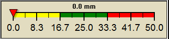 |
|
| Melt Today: | 0.00 mm |
| Yesterday: | 0.00 mm |
| Last 7 Days: | 0.00 mm |
| Rain: | 0.00 mm |
|
to Date Avg:10 |
0.00 mm |
|
to Date Diff from Avg:10 |
|
| Avg: | 0.00 mm |
| Diff from Avg: |
|
| Season:1 | mm |
|
YTD Avg:11 |
0.00 mm |
|
YTD Diff from Avg:11 |
|
| Last Rain Time/Date: |
-- at |
| rain days in | |
|
days in days since last rain |
|
| Current: | mph |
| 1Hr Average: | Calm |
| Wind Run: | miles |
| Wind Gust | |
| Current: | mph |
| Today: | mph |
| Month: | mph - |
| Year: | mph - |
| Record Gust: |
mph -- |
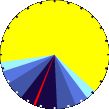
Sunlight:
|
|
|
Waxing Gibbous |
|

|
|
|
79% Illuminated |
| Sun Spots6 |
Sunspots Yesterday 168 |
| Current: |
|
| Last Hour: |
|
| High : | % |
| Low : | % |
| Record High: |
% -- |
| Record Low: |
% -- |
| Current: | mb |
| Last Hour: | |
| High : | |
| Low : | |
| Record High: |
mb -- |
| Record Low: |
mb -- |
| Today: | |
| : | |
| to Date: | |
| Cooling Degree Days | |
| to Date: | |
| Today: | 0.00 cm |
| Yesterday: | 0.00 cm |
| Snow: |
|
| Avg: | 0.00 cm |
| Diff from Avg: | 0.00 cm |
| Season Total:2 | 0.00 cm |
| Snow Depth: | 0.00 cm |
| snow days in | |
| snow days this season.2 | |
|
First Snow of Season: -- |
|
|
Average 1st Snow: |
|
| Current: | °C |
| Low : | °C |
| Yesterday: | °C |
| Record: |
°C -- |
|
May-18 4.8 |
May-19 4.9 |
May-20 4.9 |
| Currently: | |
| YTD Avg Temp: | °C |
| Sunrise: | 05:06 |
| Sunset: | 21:10 |
| Moonrise: | 15:34 |
| Moonset: | 03:31 |
| Full Moon: | 23-May-2024 |
| New Moon: |
12:38 GMT 06-Jun-2024 |
| Updated at Midnight | |
| Current ET: | 0.00 mm |
| 7-Days Rain: | 0.00 mm |
| 7-Days ET: | 0.00 mm |
| 7-Day: |
|
| : |
|
Help Support this Site! |
| If you find the information useful on this site please consider making a donation. | |

Your business |
|
| HIGHS: | LOWS: |
|
°C -- |
°C -- |
| Daytime Records | |
|
°C
|
°C |
| Nitetime Records | |
|
°C |
°C |
|
ICN: | S3C2:1 ajaxWDwx3 ISS: | CON: | RCP: |
|


